
Features Klix App
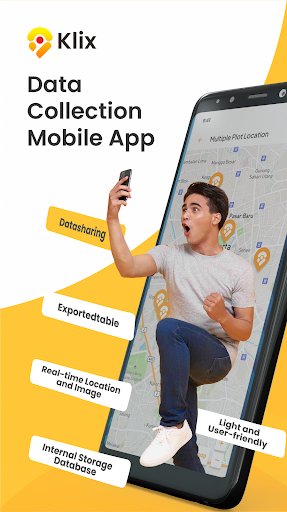
Klix App is an android-based mobile application that can be used to record location (latitude and longitude) that is associated to the acquired images through mobile phone camera and textual description about the images or location.Klix Apps is location and images are stored in mobile phone storage.
The images and location can be sent to any emails.
The email recipients will receive spreadsheet table which contains columns of latitude, longitude, textual description and associated image file name.
The images will be bundled in a compressed-file.Klix App recorded location can be plotted in google map, openstreetmap, Here maps and any installed mobile-phone-based map application.
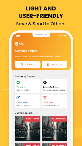
The spreadsheet table is easily to be imported into any mapping and GIS software.Klix App does not require dedicated server to run the application or to store the data; anyone can gain benefits of using this application.
Below are some ideas:- Plantation, Agriculture and Forestry sectorAcquire tree, plant and fruit condition that based on its location, then send report to main control-room or supervisor.Deliver evidence of fertilization and harvesting.- Petroleum and Mining sectorRecord hazard potential issues, then report with description of its location to HSE management.Wellsite geologist can acquire image of ditch cuttings and cavings for report which associated to the well location.- Logistics, Retail and Manufacturing sectorWrite and record evidence of goods delivery with its location and image-proof.Record retail store visit and gain accumulation of micro-business location and networks.- Financial Services and Insurance sectorCustomer visit report and the follow up actions description.Record accident location and description.- Surveys, Statistics and Mapping sectorsLand parcels, building, housings images and location.Subject of statistics census record and description for the household information.- Government sectorTax subject location and information, to increase government income from tax collection.- GeologyAcquire images of outcrops and helps to write geological description.
The outcrops then can be plotted into maps to help regional interpretation.- Architecture, Engineering, ConstructionReport project progress, identify road potholes and its location, compare construction progress on a daily basis.
Social Features
Connect and share with friends and the community.
Camera Features
Advanced camera features with editing capabilities.
Food & Dining
Discover recipes and order food from your favorite restaurants.
See the Klix App in Action
Get the App Today
Available for Android 8.0 and above